
Invented by Matthew Tyburski, Nigel DOUGLAS, Martin MILNES, Global Surface Intelligence Ltd
Earth observation and analysis have traditionally relied on manual interpretation of satellite images, which is time-consuming and prone to human errors. However, with the advancements in image-based machine learning, it is now possible to automate the process and extract valuable information from large datasets in a fraction of the time.
One of the key drivers of this market is the need for precise and timely information in sectors such as agriculture. Farmers can use image-based machine learning systems to monitor crop health, detect diseases or pests, and optimize irrigation and fertilization practices. This enables them to make data-driven decisions and improve crop yields while minimizing the use of resources.
Similarly, in the forestry industry, image-based machine learning can be used to monitor tree health, detect forest fires, and assess the impact of logging activities. This helps in sustainable forest management and conservation efforts.
Urban planning and infrastructure development also benefit from image-based machine learning systems. By analyzing satellite images and aerial photographs, city planners can identify areas prone to flooding, monitor land use changes, and plan for future development. This technology can also be used to assess the impact of climate change on coastal areas and help in disaster management and mitigation.
Furthermore, image-based machine learning systems play a crucial role in environmental monitoring and conservation. By analyzing satellite imagery, scientists can track deforestation, monitor wildlife populations, and assess the health of ecosystems. This information is vital for understanding the impact of human activities on the environment and formulating effective conservation strategies.
The market for system and method using image-based machine learning process for earth observation and analysis is highly competitive, with several key players offering a wide range of solutions. These companies develop advanced algorithms, build robust image processing platforms, and provide comprehensive data analytics tools to extract meaningful insights from earth observation data.
In conclusion, the market for system and method using image-based machine learning process for earth observation and analysis is witnessing significant growth due to the increasing demand for accurate and efficient solutions in various industries. This technology has the potential to revolutionize the way we monitor and analyze the Earth’s surface, enabling us to make informed decisions and take proactive measures to address environmental challenges. As the technology continues to evolve and improve, we can expect to see even more innovative applications and solutions in the future.
The Global Surface Intelligence Ltd invention works as follows
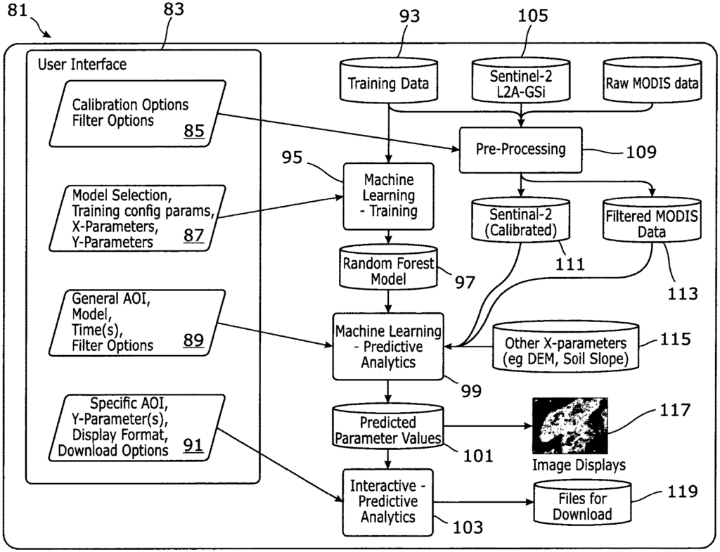
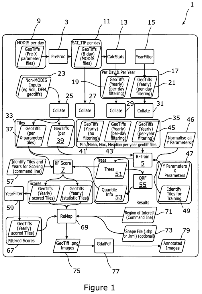
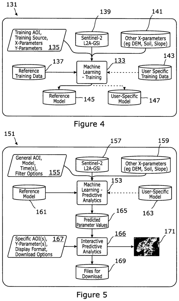
A process for Earth analysis and observation by pre-processing remotely sensed images, which can be from MODIS, Proba-V or Landsat, or any other airborne or spaceborne sensor. The images are filtered by applying a temporal filtering process to a series of remote sensing pictures and extracting descriptive statistics to the pixels in the remote sensing photos to create the input X parameters that will be used for a machine-learning process. The machine learning process is used to create a new model that determines the mapping between the input X parameter values and the range of Y parameter values. This improves the RAM allocation in the software, and the parallelizing during the machine-learning process. The output of machine learning is applied to a new Area Of Interest in order to predict or determine Y-values based on the X-values. “Generating calibrated images that correspond to the specific areas defining the Areas of Interest.
Background for System and Method using Image-Based Machine Learning Process for Earth Observation and Analysis
Manual interpretation of remote-sensing imagery with commercial software can be time-consuming and expensive. The human element of manual interpretation also introduces an additional level of error. The error may be due to a combination poor analysis or sensor errors (cloud cover, atmospheric distortion or geographic projection, for example). These single-image observations are also often made at a snapshot in time or a single moment in time. This means they are out of date both the instant they are taken and the next interval in time (daily. weekly. monthly. etc.). This can produce new values at the same location. This can also skew the results of imagery analysis, particularly when it includes incremental replication within and between years. “A system that aggregates the temporal replication of satellite images could reduce errors while simultaneously increasing processing time for imagery analysis.
According to a first aspect, a method for Earth observation and analyses is provided. The process comprises:
The present invention is advantageous because it uses pre-processing for better data, and machine learning for faster data processing. This results in a higher quality image output to the user.
Data scoring is the process of predicting future behaviour using a model.
Preferred, the area is defined by the bounding coordinate box of the target.
The output image can be annotated, scaled and colour-coded.
Preferably, extracting descriptive statistics includes extraction from individual pixels.
The data should include independent variables (X parameters) such as satellite data.
The satellite-derived data includes imagery from MODIS, ProbaV, Landsat, Sentinel, or any other airborne or spaceborne sensor.
The data should preferably include Discrete Element Method (DEM) derived parameter (such as slope aspect elevation).
Preferably the signal processing smoothes the noise of each pixel over a period of a year, or in relation to growth cycles within that year.
Preferably the descriptive statistics should be extracted from the statics of the pixel’s filter frequency.
When comparing values, it is preferable to run the signal processing between years.
Preferably the signal processing filters includes Fourier processing.
The signal processing filter should preferably include Kalman filtering as well as smoothing.
The signal processing should preferably include generating descriptive statistics based on annual or growth seasons.
The descriptive statistics should include the annual minimum, median, mean, and maximum values for each pixel in an image.
The descriptive statistics should be used to calculate the vegetation attributes.
The predetermined area should preferably consist of global tiles or a specific Area Of Interest.
Preferably image data comprises min/mean/max/median values across images acquired.
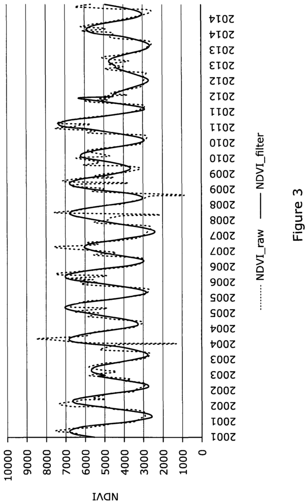
It is preferable to use a signal processing filters in order to reduce the impact of anomalous data values.
Click here to view the patent on Google Patents.
Leave a Reply