Invented by Jianhui Xu, Huihua RUAN, Ji Yang, Hongda HU, Kaiwen ZHONG, Chenghu ZHOU, Guangdong Meteorological Observation Data Center, Guangzhou Institute of Geography of GDAS
Satellite precipitation data plays a vital role in understanding and predicting weather patterns, especially in regions where ground-based observations are limited. However, satellite data is often available at coarse spatial resolutions, which may not be sufficient for localized studies or applications that require fine-scale information. This is where the Spatial Autocorrelation Machine Learning-based Downscaling Method and System come into play.
This method utilizes advanced machine learning algorithms to downscale satellite precipitation data from coarse to fine spatial resolutions. It takes into account the spatial autocorrelation of precipitation, which refers to the relationship between precipitation values at nearby locations. By incorporating this autocorrelation information, the downscaling method can generate high-resolution precipitation data that accurately captures the spatial variability of rainfall.
The system consists of a combination of satellite data, ground-based observations, and meteorological models. It uses historical precipitation data to train the machine learning algorithms, which then learn the relationship between satellite observations and ground-based measurements. Once trained, the system can downscale future satellite data in real-time, providing users with high-resolution precipitation information.
One of the key advantages of this method and system is its ability to capture localized precipitation patterns accurately. This is particularly important for applications such as flood forecasting, where accurate information about rainfall intensity and distribution is crucial. By providing high-resolution precipitation data, the method and system enable better predictions and early warnings for potential flood events.
Moreover, the Spatial Autocorrelation Machine Learning-based Downscaling Method and System also find applications in climate change studies. As climate change continues to impact precipitation patterns, it is essential to understand how rainfall is changing at local scales. This method allows researchers to analyze long-term trends in precipitation and assess the impact of climate change on specific regions.
The market for this method and system is driven by the increasing demand for accurate and localized precipitation data. Various sectors, including agriculture, water resource management, and disaster management, rely on precise rainfall information for decision-making. The ability to downscale satellite data and provide high-resolution precipitation data opens up new opportunities for these sectors to improve their operations and mitigate risks.
Additionally, advancements in machine learning algorithms and computing power have made it easier to implement this method and system. The availability of large datasets and improved computational capabilities enable faster and more accurate downscaling of satellite precipitation data. This has further fueled the market growth for this technology.
In conclusion, the market for Spatial Autocorrelation Machine Learning-based Downscaling Method and System of Satellite Precipitation Data is witnessing significant growth due to the increasing demand for accurate and high-resolution precipitation information. This method and system offer a reliable solution for downscaling satellite data, enabling better predictions and decision-making in various sectors. With ongoing advancements in machine learning and computing technologies, the market is expected to expand further in the coming years.
The Guangdong Meteorological Observation Data Center, Guangzhou Institute of Geography of GDAS invention works as follows
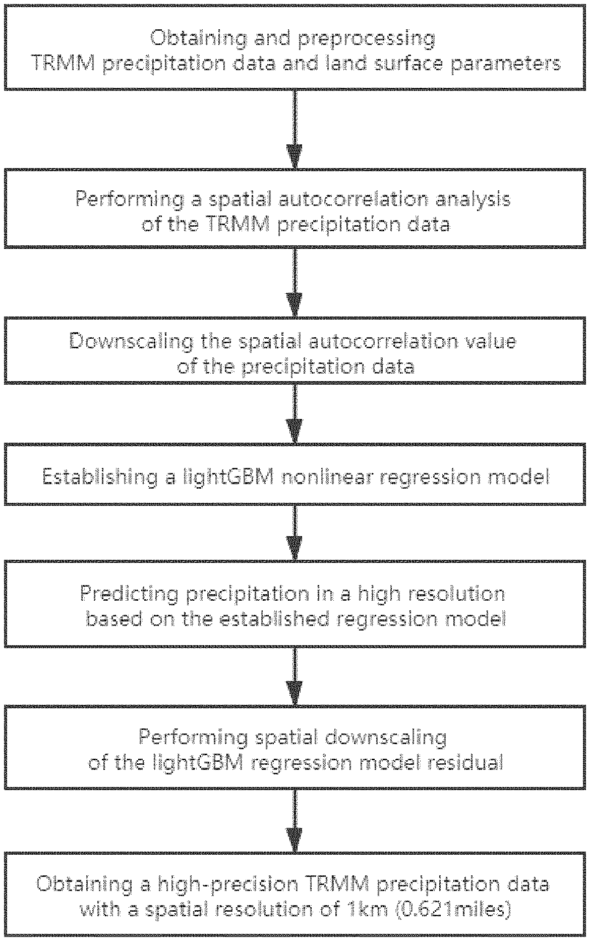
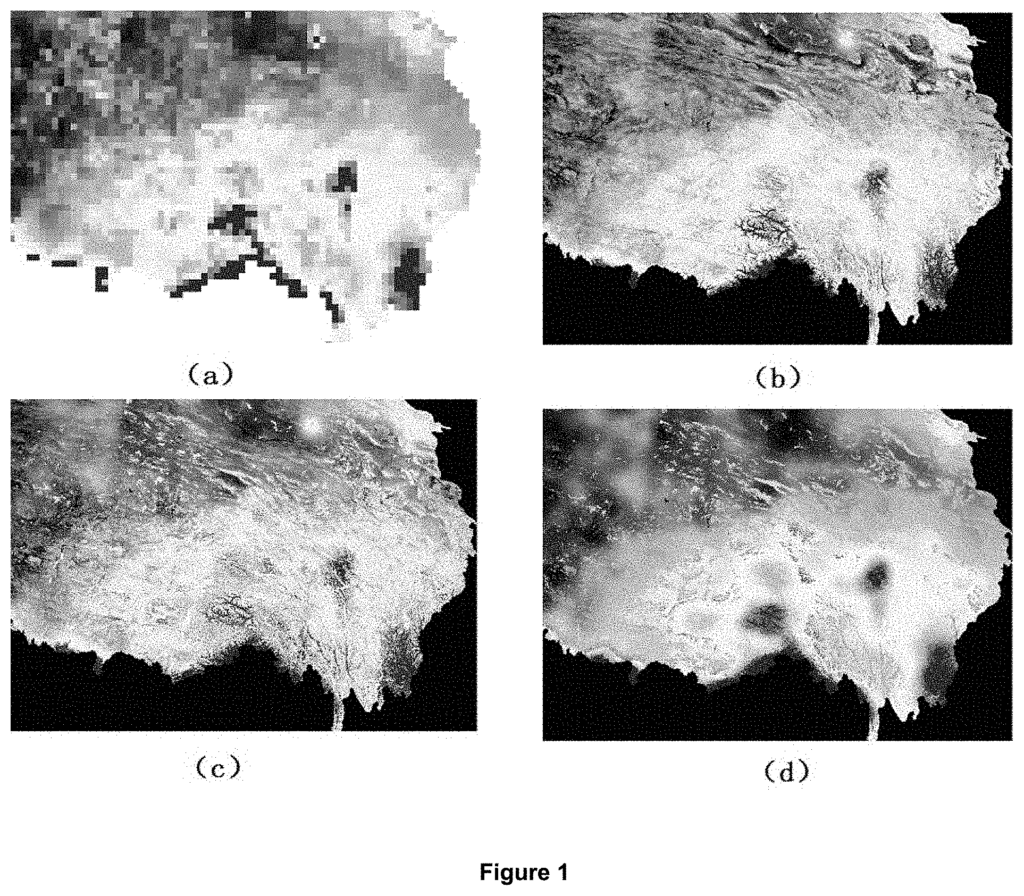
The method includes obtaining satellite precipitation and TRMM data; preprocessing land surface data to obtain DEM (day land surface temperature), night land surface temperatures, and day-and-night temperature differences; and performing a spatial-autocorrelation-analysis of the TRMM data to estimate the spatial-autocorrelation-value of the data at a resolution of 25km; reducing the spatial-resolution of the spatial-autocorrelation-value of the data from 25km to 1km; establishing a “A system and terminal are also provided.
Background for Spatial Autocorrelation Machine Learning-based Downscaling Method and System of Satellite Precipitation Data
Some progress has been made on the research of spatial downscaling techniques for satellite remote sensing data. The main research ideas are to establish a regression model for precipitation and land-surface parameters at a low resolution scale and then use the regression model with high-resolution parameters of land-surfaces in order to estimate high-resolution rainfall data.
There are two shortcomings, however. The established regression model between land surface parameters and precipitation does not take into account the spatial autocorrelation of precipitation. This will result in a loss of spatial data of precipitation as well as uncertainty for the model. “On the other hand only traditional interpolation methods such as spline or others are used to correct residuals, without taking into account the difference in area element scales before and after the downscaling, and the inherent spatial relativity of the data. This will cause a certain loss of precision to the downscaling result.
After searching, we find that:
1. Chinese Patent Publication No. The CN107608939A published on January 19, 2018 entitled “Method of Downscaling TRMM Data Based on High Resolution Satellite Data” discloses a technique for downscaling TRMM data using high resolution satellite data. This method uses official meteorological satellite data to obtain TRMM remote sensing data. Then, it corrects the data using a Leave One Out cross-validation technique. After selecting variables by step regression based on the factors that affect precipitation, the lag between vegetation and precipitation, as well the spatial correlation between vegetation are taken into consideration to create a multi-spatial model. The optimal model for downscaling precipitation is then selected. This method is accurate and simple for predicting precipitation. This method has some problems.
(1) This method establishes only the regression model between precipitation and independent variables. It does not take into account the nonlinear relationship, nor the spatial autocorrelation of satellite remote sensing data, or the inherent spatial autocorrelation of precipitation in the geographic process.
The downscaling will result in a loss of precision due to the inherent spatial correlation and the differences between the surface element and downscaled scales.
2. Chinese Patent Publication No. The CN109375294A published on February 22, 2019 entitled “A Mountain Area Data Downscale Correction Method” discloses a downscaling method of satellite precipitation data for mountain areas. The method involves reading TRMM3B42.V7 data from satellites and performing monthly precipitation statistics; correcting variables fusion, unifying spatial scale and creating a regression downscaling models; performing cross validation and downscaling. The present invention integrates precipitation data from mountain meteorological stations in the downscaling process of satellite data. It optimizes the method using cross-validation, takes full advantage of the limited observation data available in mountainous regions, and improves accuracy and consistency of the measured data after downscaling. The downscale technique based on multi-method review and comparison has also preliminarily resolved the problem of system error of a single downscale method. It has enriched the satellite precipitation data correction system and improved its reliability. The method is well suited for downscaling satellite precipitation products, especially in typical mountainous regions. Its results are also useful in acquiring the spatial and time distribution characteristics of rainfall in mountainous terrain. This method has some problems.
(1) This method ignores spatial autocorrelation data from satellite remote sensing data, and the inherent spatial autocorrelation properties of precipitation in the geographic process.
(2) This method doesn’t correct the residual errors of the regression downscaling models, which will cause a certain loss in precision to the results. The residual error is greater when the fit between precipitation data and the regression model of independent variable is low.
(3) This method ignores the impact of day/night land temperature differences and day/night land temperature, and only considers NDVI.
3. Chinese Patent Publication No. The Chinese Patent Publication No. CN109472393A was published on March 15, 2019. It is entitled?Method, device and electronic equipment for spatial downscaling precipitation data detection?. The 15th of 2019, entitled “Method for spatially downscaling rainfall data detection”, discloses a method of spatial downscaling of precipitation. This method includes establishing and training a random forest algorithm according to day land temperature, night land temperature, day-and night land temperature difference, digital elevation model, and vegetation index for the second resolution sample area, and also a description of satellite remote sensing data of the sample. This method of spatial downscaling precipitation data can provide high-resolution precipitation data. This method has some problems.
(1) The method that only considers the relevance of day land surface temperatures, night land surfaces temperatures, the difference between day and night land surfaces, digital elevation models, and vegetation indexes, without considering the spatial autocorrelation information of satellite remote sensing data on precipitation, while ignoring the inherent spatial autocorrelation characteristics of precipitation in the geographic process;
(2) This method uses only the traditional spline method to correct regression residuals, and does NOT consider the difference in the area element’s scale before and after downscaling, or the spatial correlation inherent to the data. These factors will cause a certain loss of precision to the results of downscaling;
(3) The random forest model is not very good at first, particularly when there is just one learner. The random forest model will usually improve as the number of learners grows. It will also overfit problems that have high noise.
In conclusion, existing technologies have yet to solve the two above shortages. Neither description nor report has been found of similar technologies, or similar materials, in the United States and abroad.
Contents of the Invention
The The The
The invention is implemented using the following technical solutions
In one aspect, the invention provides a spatial autocorrelation-based machine learning downscaling of satellite precipitation datasets, which includes
S1, obtaining TRMM rainfall data and land surface parameter;
Click here to view the patent on Google Patents.
Leave a Reply